


A severe thunderstorm warning issued by the National Weather Service office in Springfield for Douglas County and southwestern Wright County through 4:30 p.m today, Thursday, was extended to 5:15 p.m. A warning was issued for southern Howell and Ozark counties through 5:30 p.m.
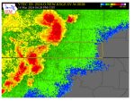
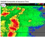
At 3:30 p.m. severe thunderstorms were located along a line extending from near Battlefield in Greene County to near Highlandville in Christian County to 6 miles northeast of Reeds Spring in Stone County, moving east at 50 mph, said meteorologists. Within 20 minutes, the storms were near Rogersville to 8 miles southeast of Sparta to near Taneyville, moving at the same pace.
By 4:14 p.m., the storms were in an area from Seymour to Ava to 17 miles northwest of Gainesville and had picked up speed, moving at 55 mph., and then at 4:25 p.m., they were seen extending from Ava to 9 miles west of Gainesville to near Diamond City, slowing back down to 50 mph.
Hazards associated with the storms include 60 mph wind gusts and half-dollar-size hail. Earlier the storms hazards were said by meteorologists to include 70 mph wind gusts and quarter-size hail.
Hail damage to vehicles continues to be expected, and aind damage is also likely to roofs, sidings and trees, officials said.
Law enforcement officials have reported to the NWS that the storm downed multiple trees in Christian County and a tractor-trailer was blown over on U.S. 160 in Stone County near Branson.
Impacted locations are Bryant Creek State Park, Ava, Brushyknob and Squires. Officials note this also includes Interstate 44 between mile markers 91 and 100.
A tornado watch is in effect through 9 p.m. for an area including Howell and surrounding counties.
Those in the area warned for a severe thunderstorm should move to an interior room on the lowest floor of a building, officials reminded.
4:07 p.m. 3/14/2024: This article was updated to include updates from law enforcement regarding damages, and an update on the storm's movement.
4:24 p.m. 3/14/2024: This article was updated to show the storms' progress.
4:34 p.m. 3/14/2024: This article previously bore the headline, "Severe thunderstorm warning issued for Douglas, Wright counties through 4:30 p.m." and has been updated to include an extension of the original warning and the addition of a newly-warned area.


